
(Est. read time: 4 min)
Dense urban construction projects — working in tightly packed old cities like Venice or Monaco—presents a variety of unique challenges for BIM and construction managers.
You need to help the project work around the pre-existing built environment, including buildings, underground elements, and the street utility network. You need to orchestrate a variety of stakeholders, including the construction workers themselves, public transport systems, and nearby business owners. And you need to help the project create a solid communications strategy to keep the general public up to date.
Lately, you’ve heard that reality data can help you to overcome these challenges, and you’d like to begin using it on your own project. But there’s too much information out there. How do you get started?
This guide will offer everything you need to know. Below you’ll find a quick reference from industry experts that explains:
- 🌍 What kind of data to capture at each phase of your project
- 👍 What makes good data
- 👷♂️ How to use that data to do your job better
!!! Important notes !!!
Accuracy: please refer to local guidelines, official resources, and client agreements. Since accuracy requirements will depend on a variety of circumstances that vary according to region and project, we won’t offer any specific guidance on accuracy below.
Project phases: actual division of phases may differ in your country. Please treat the guide below as a series of suggestions rather than hard rules.
Quick guide for data capturing recommendations
X = Recommended options, O = Optional, for higher quality.
| Phase | Drone photogrammetry | Personal photogrammetry | (Mobile) lidar |
| Design | X | O | |
| Construction | X | X | |
| As-built | X |
Design Phase
In the beginning of the project, you’ll perform 2D design of the street. Reality capture data is useful here for determining the layout of the grid, planning the width of each street, and predicting traffic flow.
🌍 Capture this data
- Drone lidar or photogrammetry
- Focus on producing topographical data
- You won’t need the last cm of accuracy
- Your goal is to get enough tolerance for when you start the more detailed design
👍 What makes good data
- Compatibility with zoning documents
- Data should use same height system, coordinates as existing zoning documentation
- Data should use same height system, coordinates as existing zoning documentation
- Coverage
- Data should including area for design
- As well as area covered by zoning documents
👷♀️ How to use the data
- Determine placement of existing built elements
- If you are renovating an old bridge, for instance, draw the borders of existing nearby houses and buildings
- If you are renovating an old bridge, for instance, draw the borders of existing nearby houses and buildings
- Plan construction
- Set boundaries for height of street to ensure access to existing and future real estate, houses, and businesses
- Plot drainage
- Plan for lightposts and other assets
- Calculate material requirements (roughly)
- Estimate costs
Construction Phase
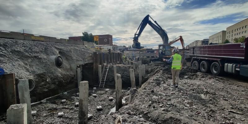
In this stage, your company will begin digging into the ground and building the roads and structures. Reality capture is extremely helpful here, since the data you capture can be used for orchestrating the work of multiple stakeholders and communicating with the general public. This will help you to respond much faster to surprises—like a 120+ year old pipe that no one knew about, or underground utilities that aren’t where they’re supposed to be.
🌍 Capture this data
- drone photogrammetry
- personal photogrammetry (DSLR or iPhone, for instance)
- Focus on the easiest and cheapest options, since these will help your stakeholders will capture more data with little effort
👍 What makes good data
- Frequency
- Get data often to record the current state of the site
- Get data often to record the current state of the site
- Coverage
- Capture the whole working area
- Ensure that all stakeholders have the data they need for the project to continue
- Accuracy
- Consider the future use-cases for the data and ensure accuracy is sufficient
- EG, record the location of elements like underground pipes, cables, wires, and other utilities that will be covered by concrete
- If the location data for these elements is not high enough, the data will be useless for future building projects
👷♀️ How to use the data
- Coordinate work between multiple stakeholders
- If opening the ground reveals four cables, for instance, use the data to help cable owners verify each cable.
- If opening the ground reveals four cables, for instance, use the data to help cable owners verify each cable.
- Produce records
- For construction in historical cities (eg, Monaco), the project will need virtual record to return site to original conditions, or better, so you’ll need to virtualize the site
- For construction in historical cities (eg, Monaco), the project will need virtual record to return site to original conditions, or better, so you’ll need to virtualize the site
- Plan re-work as needed
- Use the reality data to communicate faster with stakeholders, so you can respond faster to surprises
- Plan alternative transportation routes
- When you need to change existing roads or public transportation routes, use reality data to plan them against the current conditions on site.
- Communicate with public
- Share select data to keep the public up-to-date on construction stages, alternative routes, pedestrian closures, etc.
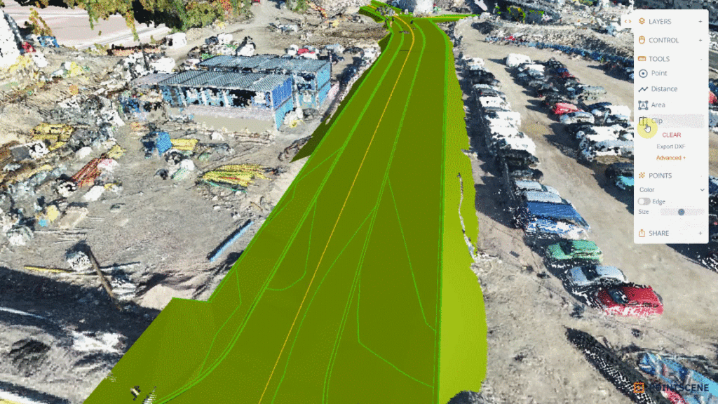
3D views
As-Built Capture Phase
Once surfaces and overground structures are constructed, reality data acts as a high-quality record of the project’s complete state, and a reference for future maintenance and potential QA disputes.
🌍 Capture this data
- High-quality mobile lidar point cloud
👍 What makes good data
Focus on gathering data that reflects the project as it was completed — as opposed to how it was originally designed. Focus on:
- Full coverage of as-built (and “as delivered”) situation,
- Including data on roadside equipment, geometry of road, etc.
👷♀️ How to use the data
Converted to the appropriate deliverables for project completion.
- Produce necessary documentation
- Street smoothness, slope, and grade
- Curb data
- Drainage locations
- Assets like lightpost
- Set a proven baseline for future regular monitoring of sagging or depression of ground or road.
- Save data for potential quality disputes regarding bad enforcement or stabilization.
- Create 3D models, asset libraries, and inventories for maintenance
Are you eager to get started? Get our Pointscene FREE Demo account now: