
BIM COORDINATORS
Effortlessly manage and utilize data in the design process
Utilize and integrate intelligent data in your workflow. Easily visualize and inspect relevant information through measurements, ortho maps and point clouds. Pointscene offers standard web services and API to integrate with a wide range of end solutions.
Visualize and track the current state of your worksite
Uploading your data to the Pointscene cloud enables you to easily view ortho maps, drone footage, point clouds and more through any device, at any time. This enables you to stay on track with today’s situation at the work site, and compare to earlier dates.
You don’t have to visit the field as often or wait for the data you need, which saves the project time and money.
Drone data
360° photo and video
Point clouds
IFC & LandXML
Terrain and ortho maps

Work with tools you already master
With integrations to a wide range of end solutions such as Autodesk, Trimble, Infrakit, Pix4D, ArcGIS and more, you can make sure that Pointscene fits into your existing workflow effortlessly.
Pointscene uses Open Standard API so you will never be locked in using a certain file type or software.
AutoCAD Civil 3D
Trimble Connect
Infrakit
3D-Win
Be.Smart Site Management
Novapoint

Keep your data organized
Pointscene centralizes all your data and makes it effortless to manage by making it easy to view, rename, organize and archive.
No more navigating deep folder hierarchies in order to get to a certain file!
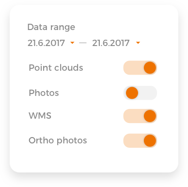
Filter by type, project, date and user
Track progression
Archive by capture dates
Design your own system
Securely store the data in the Pointscene Cloud Storage
Pointscene Cloud Storage lets you easily transfer and then store as much data for as long as you wish.
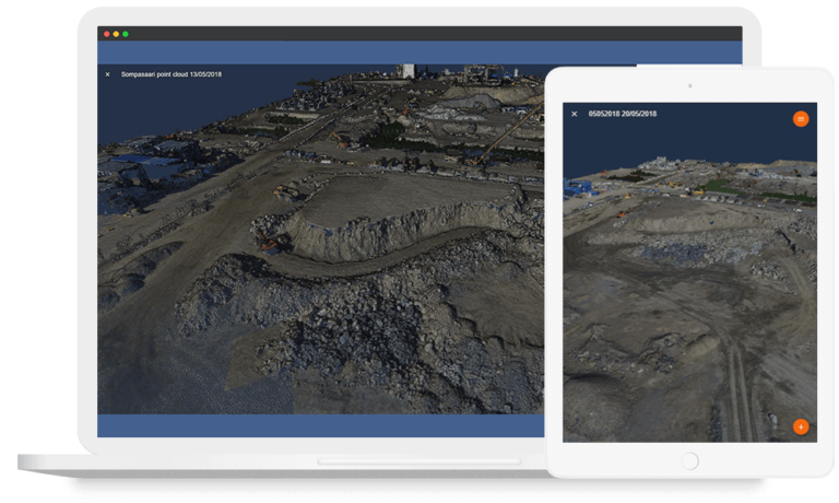
Visualize your worksite online with any device
The Pointscene online platform has built-in visualization and is always accessible with any device. Easily access the data through your desktop, tablet or mobile.
This means no more waiting for the needed data to be uploaded and less field visits, which helps you to be more efficient, and saves the project time and money.
Easily communicate with all stakeholders
Invite colleagues and stakeholders for direct access to up-to-date ortho maps and volume calculations. Grant different kinds of access such as Viewer, Editor and Owner depending on whether it is for a developer, designer, analyst or project manager.
Viewer
– Find the needed information on the map
– Observe changing circumstances
– Do weekly or monthly check-ins
Editor
– Deliver data (drone, laser scans…)
– Read and leave comments
– Weekly check-ins
Owner
– Responsible for accessibility of data
– Grant access to data
– Distribute access and roles to stakeholders
Stay on track with intelligent data
Start utilizing your worksite data and make your worksite more efficient, saving you time and money.