
Minor updates and bug fixes
We updated how Maps&Drawings layer can managed and fixed some bugs improving raster uploading, photo parsing, and external WMS handling.
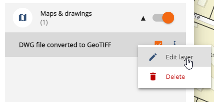
Maps&Drawings
Maps & drawings can be created by Editors/Owners by uploading a raster and selecting the data type as “Other map”. This will add the data set as a semi-transparent layer on top of all other layers. See Raster Upload for more details.
Maps & Drawings now don’t have any date restriction, and users can now edit the name of the layer and delete it.
Other fixes
- Include photo extents to initial map extend calculations
- Fixes to photo parsing
- Add warning when uploading raster without world file when header is not read
- Check type and name of raster and world file
- Remove note’s video recording option
- Update XML parser used to parse external WMS GetCapabilities response