
Image: Unsplash
(Est. read time: 4 min)
The first stages of industrial construction involve massive earthworks and laying foundations and utilities for large structures. In many ways, these projects are much like other infrastructure projects, but with a few extra challenges.
That’s because industrial construction relies traditionally on 2D drawings, and the end client is most often a factory owner who is working with a contractor—not a professional contractor themselves. This means the clients may not have the expertise to understand the drawings, which can keep them in the dark about what is happening on their site, what phase the construction is in, or even what should be and is being done next.
You might have heard that reality data can help you communicate with your industrial construction clients, and help them to keep track of construction progress. But how do you get started?
This guide will offer everything you need to know. Below you’ll find a quick reference from industry experts that explains:
- 🌍 What kind of data to capture at each stage of your project
- 👍 What makes good data
- 👷♂️ How to use that data to do your job better
!!! Important note !!!
Regarding questions of accuracy, please refer to local guidelines, official resources, and client agreements. Since accuracy requirements will depend on a variety of circumstances that vary according to region and project, we won’t offer any specific guidance on accuracy below.
Quick guide for data capturing recommendations
X = Recommended options, O = Optional, for higher quality.
| Phase | Drone data | Lidar scans | 360 photos |
| Earthworks | X | O | |
| Construction | X | X | X |
Earthworks Phase
This construction phase is largely focused on moving large amounts of materials. Reality capture can help you and your clients understand how the project is progressing, and gather measurements to perform dimensional validation as needed.
🌍 Capture this data
- Drone orthophotos and surface models
OR - Lidar scans
👍 What makes good data
Focus on capturing the “bare” site with good:
- Coverage
- Cover a wide enough area to accommodate future phases as the project expands
- Leave enough room for modifications
- Recency
- Your data sets should clearly reflect all work completed to date, as well as any other changes to the site
👷♀️ How to use the data
Use the data to revisit your original plans and estimates, and adjust as needed.
- Create baseline surface models
- View the actual surface of the terrain
- Validate the real-world geotechnical conditions
- Replace guesses based on point-to-point information
- Determine geotechnical and mass balance values
- Determine if amounts differ from the original estimates
- Make correct cost estimates based on actual conditions
- Rework the budget with the client as needed
- Communicate with the client
- Share the aerial images and orthos with the client
- Help them to understand the real-world context for the drawings
- Keep them to date on project progress with intuitive visual information
- Have the client review, take measurements, and validate the height of construction of features like ditches
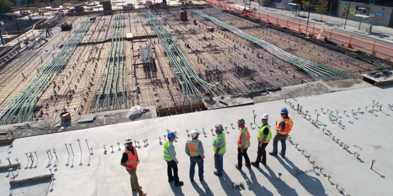
Construction
Once the land is clear, it’s time to build the concrete foundations and lay utilities.
🌍 Capture this data
- Drone orthophotos and surface models
OR - Lidar scans
OR - 360 progress photos
👍 What makes good data
Focus on capturing work as it is completed. Pay attention to:
- Recording all progress
- Make sure all significant changes are documented
- Strategic planning
- Most projects will not need to capture the entire work area in every capture—just the portions where a phase has been completed.
- During some phases, construction may move faster, and you could consider capturing once a week.
- During other phases, the work may progress more slowly, and you could consider capturing once a month.
👷♀️ How to use the data
Review construction progress, make plans for work structures and movement of machinery, and communicate with the client.
- Add extra context to drawings
- Stakeholders such as the site manager and foreman can view the reality data and the drawings together, and use this to better understand the relationship between the build work and the drawings
- They can also take notes or smartphone photos and add them to the drawing
- Verify construction
- By viewing the reality data and the drawings together, stakeholders can use a smartphone to verify that foundations are installed as planned
- Plan temporary work structures
- For example, if a parking lot is in the way of a future construction zone, use the ortho in coordination with drawings of later work phases to plan where the parking lot can go next
- Orchestrate logistics and heavy machinery movement
- As work progresses, use current orthos to plan movement of big machinery like excavators
- Use the orthos to demonstrate the path to the machine operators
- Communicate with client
- Share orthos or other visual data with the client as they are captured, and use them to clearly point out construction progress
Post-Construction
It’s possible that your interaction with the project will end here, and most of the work will be performed by a vertical construction company using complex BIM software. At this point, pass your reality data to the client, who can gain extra value.
- Add context to the as-built
- The data you’ve gathered during construction shows valuable information about the geospatial conditions. The client can use it to add extra context to the as-built.
- The data you’ve gathered during construction shows valuable information about the geospatial conditions. The client can use it to add extra context to the as-built.
Want to learn more? You can find our other Knowledge base articles here.
What to get started? Get our free demo account now!