
In the world of construction, infrastructure development, and urban planning, having a comprehensive perspective is just as vital as focusing on the details. 360° images are revolutionising how professionals in these fields view and manage their projects, providing unparalleled insights into job sites, project progress, and environmental contexts. When integrated with Pointscene’s platform, the possibilities for leveraging 360° images grow exponentially, driving smarter decisions and seamless collaboration.
What Are 360° Images?
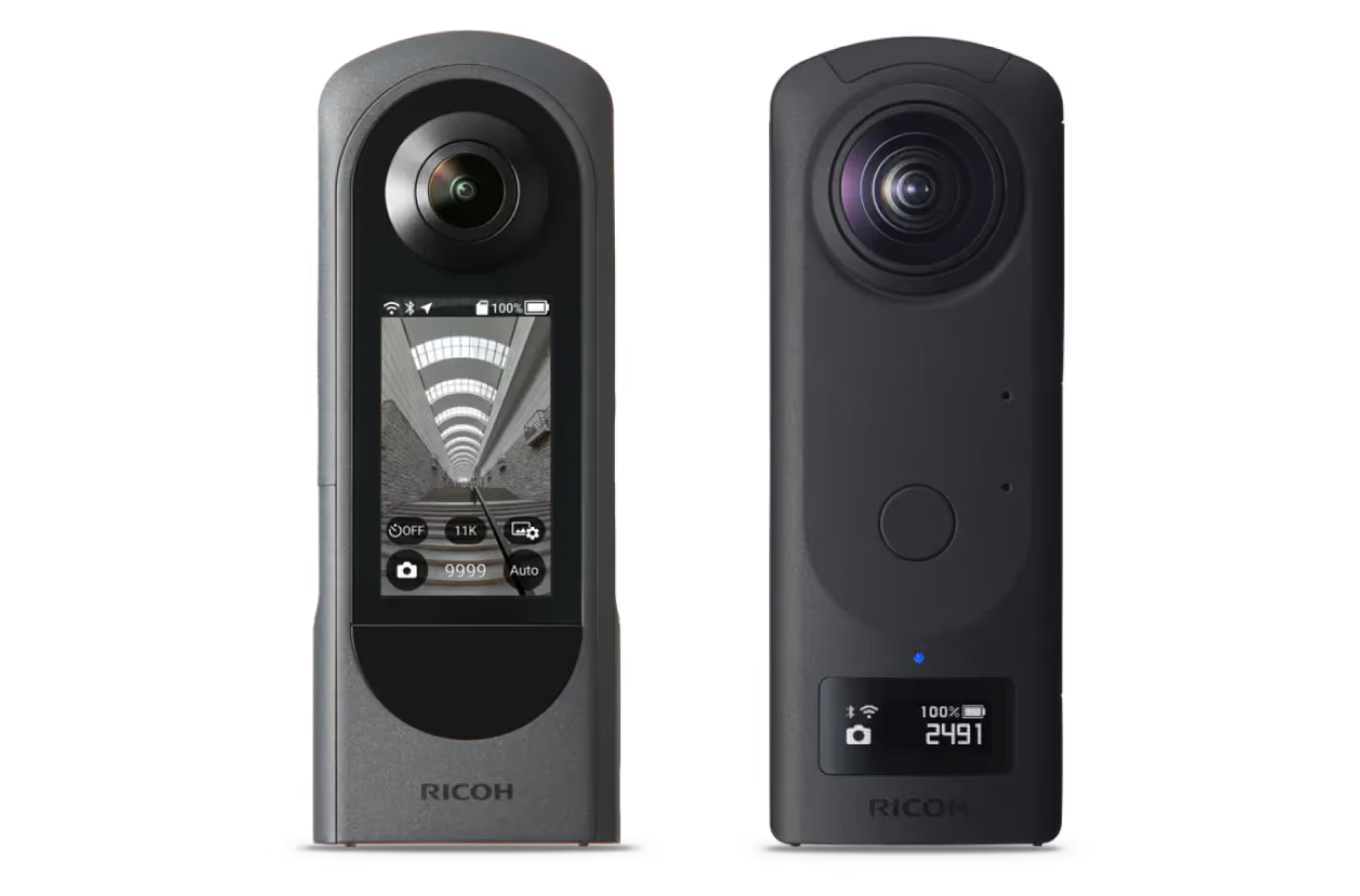
Unlike traditional photos that capture a single angle, 360° images offer a fully immersive view of a scene. These images are captured with specialised cameras, such as Ricoh Theta, or by stitching multiple photos together, allowing users to explore environments virtually as if they were physically present. This capability is a game-changer for industries that rely on detailed site understanding.
How 360° Images Enhance Workflows
When integrated into project workflows, 360° images provide several key benefits:
Improved Context: Virtual site exploration helps stakeholders understand conditions and challenges without visiting the location.
Enhanced Collaboration: Teams can share and annotate 360° images to foster clear communication and faster decision-making.
Progress Monitoring: Time-lapse sequences of 360° images document milestones and make it easier to spot deviations from the plan.
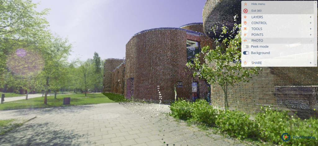
Data Integration: Professionals can create richer project representations by combining 360° images with other data layers, such as point clouds or orthophotos.
Practical Applications of 360° Images
360° images streamline various construction and urban planning processes, from safety audits to stakeholder presentations. Here are a few examples:
Remote Inspections: Conduct virtual site inspections to identify hazards and ensure safety compliance without the need for travel.
Stakeholder Engagement: Use 360° images to provide transparent updates and build trust during project presentations
Onboarding and Training: New team members should be given an immersive view of project sites, which will reduce their learning curve and improve their efficiency.
Integrating 360° Images with Laser Scanning
Pairing 360° image capture with laser scanning offers a powerful way to collect both visual and spatial data. By mounting a 360° camera on a laser scanner, professionals can gather comprehensive datasets efficiently. This combined approach:
- It saves time by eliminating the need for separate processes.
- Provides both geometric accuracy and visual context.
- Streamlines integration of visual and spatial data for better analysis.
Enhancing 360° Image Use with Pointscene
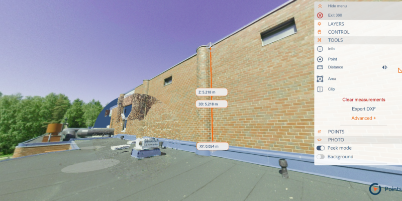
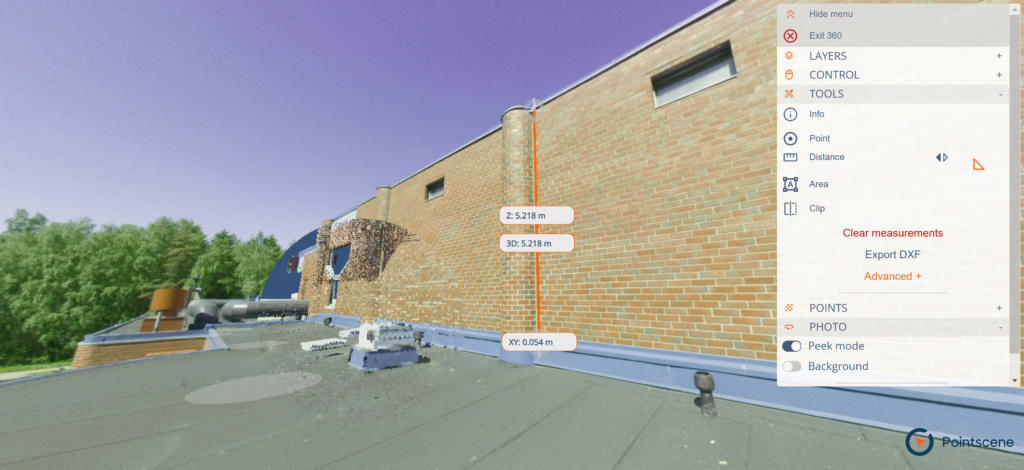
Platforms like Pointscene can enhance how 360° images are managed and utilised. By integrating 360° images into a centralised geospatial platform, teams can unlock additional capabilities, such as advanced visualisation, seamless collaboration, and detailed analysis. Pointscene’s 3D viewer possesses powerful measuring tools where users can take measurements from the 360 image when there’s also corresponding point cloud data available. This integration empowers professionals to make data-driven decisions and optimise project outcomes.
Final Thoughts
360° images are more than just visuals—they’re a transformative tool for managing and understanding project data. Whether used for site inspections, stakeholder engagement, or progress monitoring, their potential is vast. By pairing 360° images with platforms like Pointscene, you can enhance your workflows and unlock new possibilities for collaboration and decision-making.
Some of our top pics:
Revolutionizing Point Cloud Data Collection: Handheld iPhone Scanners with Enhanced GPS
Construction Site Mapping with Drones: RTK vs. Traditional Methods
Unlocking the Full Potential of Point Clouds: The Importance of Classification of Your Data